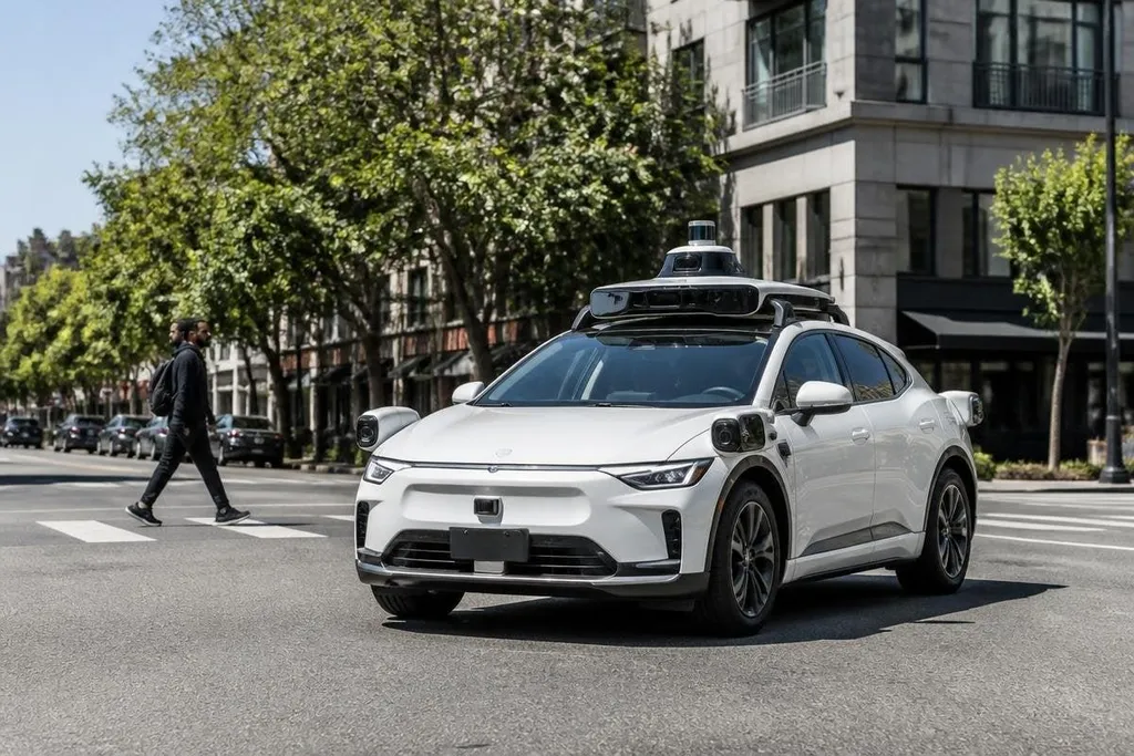
A robotaxi has to sense traffic, predict human actions, and bring a passenger to the right place without a driver touching the controls. The biggest gains have come from combining better sensors with safer software and tighter rules for where the vehicle can operate.
- Level 4 driving: The vehicle handles the trip inside a defined service area.
- Sensor fusion: Cameras, radar, and LiDAR check the road from different angles.
- Remote support: A trained operator can help when the vehicle meets a case its software cannot settle.
Driving inside a defined area
The move to Level 4 autonomy changed the engineering target. Inside a mapped operating area with known limits, the vehicle doesn't need to move safely on every road on Earth.
That boundary can cover certain streets, weather conditions, speeds, or times of day. A service can pause trips when heavy rain reduces visibility or when road work changes the route. This restriction makes testing more controlled and gives the operator a clear answer when a trip falls outside the system's design.
For a passenger, the benefit is practical. A vehicle that knows where it can work can refuse a pickup outside its service area instead of making a risky guess.
Cameras, radar, and LiDAR working together
No single sensor gives a full view of the road. Cameras read lane lines, traffic lights, signs, and object shape. Radar measures distance and speed, including when visibility drops. LiDAR sends out laser pulses to build a 3D view of nearby objects.
The software combines those readings in a process called sensor fusion. If a camera sees a dark object but cannot classify it, radar can still show that the object is moving.
LiDAR can add its distance and shape. Several measurements give the vehicle more information to check before it brakes, turns, or continues.
This matters at crossings and busy junctions, where a small error can affect a passenger, a cyclist, and several cars at once. The system also needs to spot a sensor that gives a bad reading and keep the vehicle in a safe state.
Prediction matters as much as detection
Seeing a cyclist is one task. Predicting whether that cyclist will cross the vehicle's path is harder. Robotaxi software uses the movement of nearby road users, lane position, traffic signals, and road layout to estimate what may happen next.
That estimate changes several times during a drive. A pedestrian may wait at a curb, step forward, then stop. The vehicle needs a plan that leaves room for those changes rather than steering toward one fixed guess.
Mapping supports this work. A detailed map can record lane boundaries, turn rules, stop lines, and pickup points before the vehicle reaches them. Live sensors still have to check the map against the road, since construction and parked vehicles can change the scene.
A robotaxi can follow its map and still need a remote operator when road work blocks a lane or a pickup point moves. Reports from Robot24.com can connect that handoff to the vehicle’s sensor view, response time, and safety rule before the next section looks at what happens when the link fails.
Remote support and safer failure
A robotaxi may meet a rare case that its onboard software cannot resolve. A blocked lane, an unusual police direction, or a temporary road closure can create that problem. Remote support gives the vehicle another source of help without putting a driver in every car.
The remote operator should not act like a hidden driver for the full trip. Their job is to review the scene, suggest a route or action, and let the vehicle carry out the move when its own checks allow it. The vehicle still needs to stop safely if the connection fails or no safe instruction arrives.
This is one of the less visible changes in robotaxi design. A service needs plans for faults, not only plans for normal travel. That includes sensor failure, loss of positioning, a flat tire, a blocked charging space, and a passenger who needs help.
A practical buying and deployment check
If you're judging a robotaxi service, fleet proposal, or pilot, check these points before looking at ride counts:
- Service area: Ask for the streets, weather limits, speed limits, and hours of operation.
- Sensor layout: Find out which sensors remain available after one sensor fails.
- Map updates: Check who records road work, new lane markings, and changed pickup points.
- Remote help: Ask what the operator can do, how the vehicle behaves during a lost connection, and how each event is logged.
- Passenger safety: Check the emergency stop method, support number, and plan for a vehicle that cannot finish the trip.
- Proof of use: Separate public-road operation from closed-course tests and short demonstrations.
I’d rank safer failure handling above a smoother demo. A vehicle that stops in a controlled way when its limits are reached is closer to useful transport than one that looks capable until the road changes.
The next hard test is not a quiet mapped street. It is a repeatable record of how each service handles blocked lanes, poor weather, sensor faults, and passenger problems without human control taking over.